The Birth of the Strait of Hormuz: Transforming Fertile Plains to a Flooded Basin

Ancient Rivers, Lost Landscapes, and the System Transformation of the Arabo-Persian Gulf
Introduction
Today, the Strait of Hormuz is known as a strategic chokepoint in global energy systems; however in deep time, it was something entirely different.
Before the waters of the Indian Ocean filled the basin, the present-day Gulf was not a sea. it was a fertile riverine landscape, one of the most important ecological zones in prehistoric southwest Asia.
Understanding how this transformation occurred is not only a geological question, it is a systems transformation problem, one that reshaped hydrology, ecology, human settlement, and ultimately, early civilization.
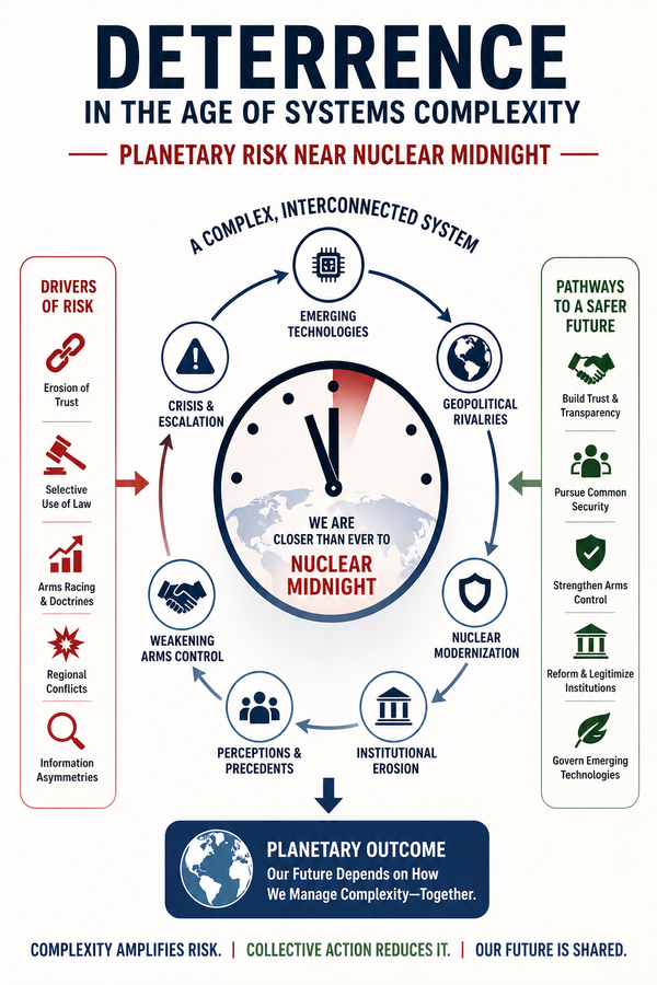
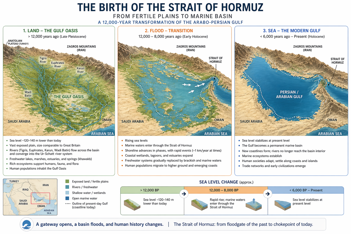
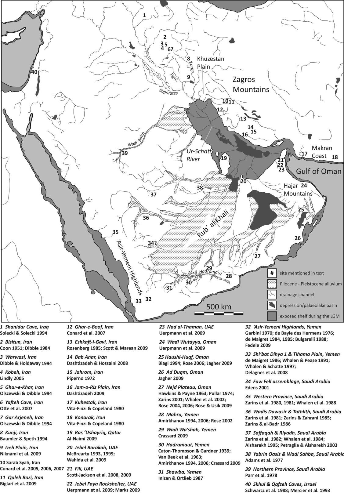
Figure 1 shows the Bathymetry of the Gulf to help understand the ancient Gulf basin and drainage systems by reconstruction of the exposed Gulf basin showing major river systems (Tigris, Euphrates, Karun, Wadi Batin) and the central depression that formed the Gulf Oasis. The contours are water depth in meters.
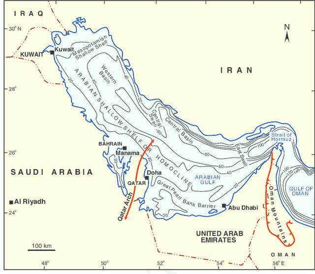
The Gulf Before the Sea: A Lost River Valley System
During the Late Pleistocene of about >12,000 years ago, when global sea levels were much lower with large portions of the Gulf basin were exposed. The region formed a vast low-lying floodplain, comparable in size at times to Great Britain. This landscape was fed by major river systems:
- Tigris River (from present-day Turkey and Iraq) as the eastern of the two great rivers that define Mesopotamia, the other being the Euphrates. The river flows south from the mountains of the Armenian Highlands through the Syrian and Arabian Deserts, before merging with the Euphrates and reaching to the Gulf. Currently, it is 1900 km (1181 mi) in length.
- Euphrates River (from present-day Turkey, Syria and Iraq) as the longest and one of the most historically important rivers of West Asia. Together with the Tigris, it is one of the two defining rivers of Mesopotamia. Currently, it is 2800 km (1740 mi) long.
- Karun River (from the Zagros Mountains of Iran), a river with the highest water flow in Iran, and the country's only navigable river. Currently, it is 950 km (590 mi) long.
- Wadi Batin (from northern Arabia) (وادي الباطن) that is nowadays an intermittent river in Saudi Arabia, Iraq, and Kuwait, the lowest and final section of Wadi al-Rummah, running 45 mi (72 km) in a northeast–southwest direction through the Al-Dibdibah plain and has been recognized since 1913 as the border between Kuwait and Iraq
These rivers merged into a major drainage system known as:
The Ur-Schatt River Valley
where Ur is in reference to a major Sumerian city-state in ancient Mesopotamia, and Schatt is a basin with water. Shatt al-Arab originally extended to the Ur Schatt river system that fed the Pleistocene/Holocene Gulf Oasis, a system of linked lakes and flood plains that stretched to the Strait of Hormuz and emptied into the Gulf of Oman. This Oasis system flooded in the period 12,000 - 7,000 BCE to form the present-day Gulf. This system flowed southeastward into a large internal basin located roughly 140 meters below present sea level.
Figure 2 shows the Pleistocene drainage systems converging into the Ur-Schatt River Valley, illustrating the integrated hydrological system of the ancient Gulf basin.
Ecology of the Gulf Oasis
This ancient basin was not barren. It was a complex and productive ecosystem, including river floodplains, freshwater marshes, estuaries, mangrove swamps, and subterranean freshwater springs (khawakb). These springs, still observed today in Bahrain, originated from deep aquifers and provided continuous freshwater supply.
The Gulf Oasis may have been one of the largest and most stable freshwater environments in southwest Asia.
Human Landscape: A Prehistoric Refugium
This environment supported human populations for tens of thousands of years. The Gulf Oasis likely served as a demographic refugium during arid periods, a migration nexus between Africa, Arabia, and Eurasia, and a center of early cultural development.
When surrounding regions became hyper-arid:
Populations contracted into this fertile basin.
When conditions improved:
Populations expanded outward.
This created a dynamic push–pull system of human movement.
The Flooding (12000 to 7000 BCE): Opening of the Strait of Hormuz
The transformation from land to sea was gradual, but punctuated by rapid phases. Between approximately 12,000 and 6,000 years before present, the Indian Ocean advanced into the basin. This marine transgression flooded over 1,000 km inland, occurred in phases, including rapid advances, and at times advancing ~1 km per year.
The Role of the Strait of Hormuz
The Strait of Hormuz was the critical gateway through which this flooding occurred. It functioned as a hydraulic threshold, a control point for marine incursion, and a system boundary between ocean and basin.
As sea levels rose:
The Strait enabled the transformation of a continental ecosystem into a marine system.
Environmental Transformation
The flooding occurred in three stages:
- Stage 1: River Valley (Pre-12,000 BP, before present) of an active river system, extensive floodplains, and freshwater-dominated environment.
- Stage 2: Transitional Wetlands (12,000–9,000 BP) of rising water table, marshes and estuaries, and mixed freshwater–brackish system.
- Stage 3: Rapid Marine Incursion (9,000–8,000 BP) of accelerated flooding, coastal advance, and loss of terrestrial habitats.
- Stage 4: Fully Marine System (after ~6,000 BP) of modern Gulf conditions, marine sedimentation, and stabilized sea levels.
Human Consequences: Displacement and Transformation
The flooding had profound effects on human populations by displacement of communities from the basin, migration to surrounding highlands and coasts, and emergence of new settlement patterns. This corresponds with rapid increase in coastal settlements, appearance of Neolithic communities, and development of irrigation and agriculture.
From Oasis to Civilization
Within a few millennia, populations resettled along the new shoreline, trade networks emerged, and early agriculture developed. This process contributed to:
The formation of early Mesopotamian civilization.
Systems Insight
This transformation illustrates a fundamental principle:
Infrastructure and geography are not static — they evolve through system-level transitions.
The Strait of Hormuz represents a geological boundary, a hydrological control point, and a long-term system transformer.
Conclusion
The Strait of Hormuz is often viewed through the lens of modern geopolitics; but its deeper significance lies in its role as:
A gateway that transformed one of the most fertile prehistoric landscapes into a marine system.
Understanding this transformation provides insight into human migration, environmental change, system resilience, and the origins of civilization.
The transformation of the Gulf basin from a fertile riverine landscape into a marine system offers a powerful analogue for contemporary sea-level rise. The archaeological and paleoenvironmental record suggests that even gradual changes in sea level can trigger nonlinear system responses, including rapid shoreline migration, ecosystem shifts, and large-scale human displacement. These dynamics are especially relevant today in low-lying, densely populated regions such as Southeast Asia (e.g., the Mekong Delta, Jakarta, Bangkok), South Asia (e.g., the Ganges–Brahmaputra Delta), and coastal Africa, where critical infrastructure, food systems, and freshwater resources are tightly coupled to coastal stability. As in the ancient Gulf, rising seas do not simply inundate land, they reconfigure entire socio-ecological systems, forcing adaptation, migration, and innovation. The key lesson is that resilience planning must move beyond static defenses to embrace dynamic, system-level strategies that integrate hydrology, infrastructure, population movement, and economic continuity. The past, in this case, is not distant, it is a preview.
Key Source
- Jeffrey I. Rose (2010), New Light on Human Prehistory in the Arabo-Persian Gulf Oasis